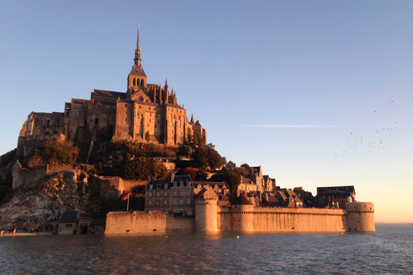
Mont Saint-Michel. Image: Amelia Duggan
An island fortress off the coast of Normandy, Mont Saint-Michel makes quite a first impression — although it pays to approach with caution
View online at natgeotraveller.co.uk
Stepping on to the ferry deck, my 3am excursion suddenly doesn’t seem such a bright idea. I eye the white railings, beyond which there is just blackness, and imagine the headlines: ‘Overboard in storm: idiot wearing slippers staring at the moon’. I look up. There it is: a swollen, burnt-orange orb glowing among flecked constellations – a rare supermoon lunar eclipse. But there’s a pounding gale outside, so I don’t linger. I’ll be getting enough of treacherous tides later.
The sun is high in the sky by the time I reach the bridge. It’s an elegant kilometre-long wooden jetty – a fine brushstroke across a spectacular bay of emerald marshland, glistening mud and flashing seawater pools. Up ahead, a distant mound of stone and greenery crystallises into a vertical island fortress as I approach. Sheer stone walls and ornate gothic buttresses soar out of the island’s forested crown. The gabled roofs of crooked medieval houses crowd the lower slopes, encircled by a formidable rampart.
Today is the Christian feast day of the archangel Michael and I’m striding from the Norman mainland towards his most iconic shrine – the medieval abbey of Mont Saint-Michel, from which the island takes its name. I’m here to witness another lunar event, a supertide – a powerful, amplified surge of water that occurs once or twice a year in only a handful of places.
“Le Mont was the only part of the French coast never to fall during the Hundred Years’ War,” Ludovic, my guide, tells me at the sloping entrance courtyard. “Let’s go see why the island was undefeatable.” An hour later Ludovic is up to his waist in quicksand. It’s all part of a rather unnerving interactive lesson – part historical, part survival; I too am standing on sucking, gelatinous sand, and have been told to paddle my feet to stay above ground – which I’m doing frantically.
“The quicksand killed many attackers,” Ludovic explains, throwing his weight to one side and hauling one leg out of the gloop, “but also many pilgrims. At low tide the bay could suddenly become foggy, people got lost, and when the tide rushed back in… game over.” Stabbing his staff into firmer terrain he calmly drags himself to safety. He helps me to extract my ankles. “People still get stranded occasionally, but now we have a helicopter team.”
Ludovic grew up on this stretch of Norman coast, experiencing the sea’s daily arrival and departure. But low tides here will one day be a thing of the past, as will Ludovic’s job as a bay guide. A £150 million conservation project, completed in 2015, has started to reverse the damaging build up of silt. Over a period of many years, the bay will lower and the island will once again become just that: an island, surrounded by water.
Little streams are beginning to appear, heralding the 40mph ‘mascaret’ wave that’s only a few hours away. I’m eager to get to high ground but Ludovic insists on explaining the astronomy behind the approaching tide by sketching out a series planetary diagrams in the sand. Confusion is written across my face, so he draws them again, larger. He tells me that schoolchildren can grasp this. Eventually we give up and, barefoot, hurry back to the island, where we part ways.
That evening, by the time I reach the lower battlements, sea has swallowed the bay, buffeting the island in rhythmic waves, and the low bridge has become submerged, cutting the island off.
After a short while, the tide begins to ebb. I’m now standing on the bridge with my bare feet in the freezing water watching the sun sink through a blood-red sunset – apocalyptic in its hue and intensity. A pale moon is already hovering on the opposite horizon. I meditate on Ludovic’s diagrams, wishing astronomy was my strong suit.
Published on natgeotraveller.co.uk


